
A Guide to Cycling Mont Ventoux via Bédoin – a bucket list ride.
It’s the undisputed ‘Giant of Provence’ and cycling Mont Ventoux via Bédoin is a bucket list climb for many. Each year thousands of cyclists make their way to the small town to test themselves against this Tour de France legendary climb. This approach of the 21km Hors Categorie climb can be a real leg breaker with an average gradient of 7.4% so make sure to pace yourself for what lies ahead.
Gradual from the start
When you set out to ride Mont Ventoux from Bédoin you will be climbing straight from the outset. The good news though is the first section of the climb contains the gentlest slope. This is somewhat telling in just how hard the overall climb is as the first section does skew the average gradient. Keep this in mind and let yourself ease into a good rhythm, you will be happy you did once you start hitting the double-digit gradients to come.
Steep through the forest
With the early kilometres past you, now the real test of the mountain begins. As the road climbs you are well into the forest. This section is notorious for bringing with it the steepest gradients. Indeed you will be faced with an average incline of around 10% for much of this part of the climb. It can feel never-ending and somewhat relentless, especially as the road itself is relatively straight which gives the impression you aren’t making progress. The forest however does provide you with some shade and protection from both the heat of the sun and wind. A welcome relief of sorts.
Chalet Reynard – the first landmark to aim for
The first major landmark of the climb is Chalet Reynard which comes just as you make your way out of the forest. It was on the approach to the Chalet in 2016 that Chris Froome infamously was reduced to running, after an incident with the Tour de France motorbike saw his bicycle damaged. The road to the summit veers around to the left at Chalet Reynard and the bare slopes of the mountain is laid ahead of you. The steepest part of the climb is now behind you, and whilst you will hit double-digit gradients in the remaining third of the climb, the average from here is just over 4%. After the steep forest road, this will almost feel relatively ‘flat’!
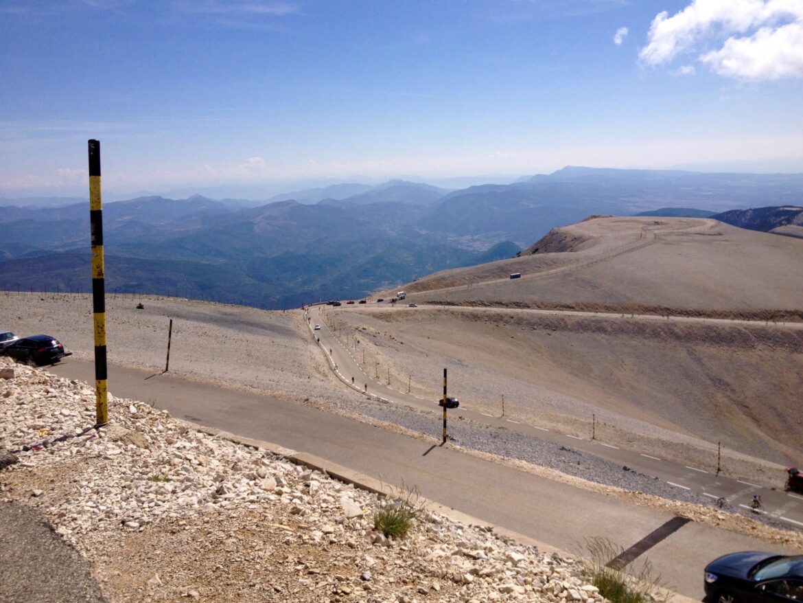
Bare slopes lead to the summit
From here the road to the top is lined with snow indicator poles. You can see the road carved into the bare slopes of the mountain and the red and white weather station aerial at the top reveals itself. The landscape here is barren thanks to the deforestation which took place centuries ago. From as early as the 12th century the trees were felled and taken to Toulon to be used to construct naval ships.
Due to the lack of trees, it is on this section of the climb that you will need to be wary of any high winds as there is no shelter from strong gusts. The wind on Ventoux is said to blow at more than 90kph for 240 days of the year and there are no shortages of stories and videos of cyclists being blown around on these notoriously windy slopes. It is apt then that the name Ventoux in French translates o meaning windy!
Tom Simpson Memorial
Approximately one kilometre from the top of the summit lies the memorial to Tom Simpson. It was close to this very spot that tragedy struck on the slopes of Mont Ventoux during the 13th stage of the 1967 Tour de France. The British rider and former world Champion unfortunately collapsed and died on the side of the road. His death was attributed to amphetamines which were commonly used by riders of that era during the Tour. Each year cyclists stop at the memorial and often leave behind a cycling cap or bidon in tribute to the fallen rider.
Steep gradients to the top
The final kilometre to the top sees the gradient steepen once more with an average of around 10%. The final hairpin is steeper still but you know you have made it once you’ve come this far now. At the summit, you will no doubt be joined by other cyclists, and during the summer months, there are also roadside vendors selling food. Of course, you will want to take a summit photo to savour the moment of cycling Mont Ventoux via Bédoin – the hardest approach. All that is left to do now is reaping the reward of all that climbing, a descent the whole way back to Bédoin!
Suggested cycling route
Distance: 41.9km / 26mi
Start elevation: 314m / 1030ft
Max elevation: 1,911m /6,270ft
Metres climbed: 1,572m / 5,157ft
Metres descended: 1,572m / 5,157ft
Categorised climbs: 1
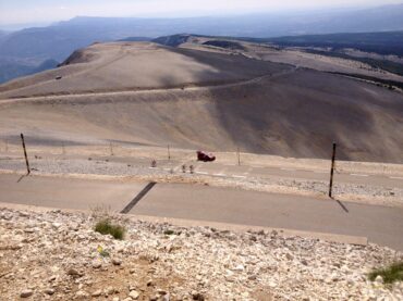
The bare slopes of Ventoux are iconic.
Food and water
Make sure to set off from Bédoin with plenty of food and water. You will be able to refuel at Chalet Reynard and also at the summit.
Highlights
- An iconic ride up one of the legendary climbs of the Tour de France
- The barren, rocky slopes of Mont Ventoux are unique to this iconic climb – it’s almost feels like you could be riding on the moon.
- Stop to pay your respects at the Tom Simpson Memorial.
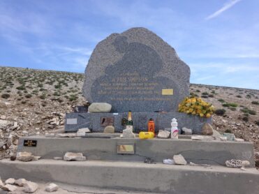
The memorial to Tom Simpson can be found just a short distance from the summit.
Climb statistics and gradient profile
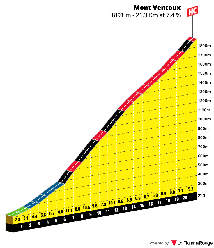
Mont Ventoux (Bédoin)
Length: 20.7km / 12.86mi
Average gradient:7.4%
Start point: Bédoin
Elevation at top: 1911m / 6270ft
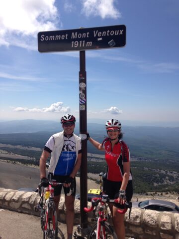
A summit sign photo is obligatory when climbing Ventoux!
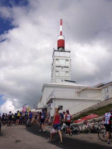
The iconic red and white aerial mast at the summit is an iconic symbol of the climb.
The climb of Mont Ventoux via Bédoin is just one of many great rides you can discover whilst you stay in the Luberon and Provence regions of France. We have mapped out several other rides which you may also wish to consider and you can read more about them here.
If you are interested in a holiday in this area of France then check out our destination guide. We have listed out lots of helpful information such as travelling to and from the region, accommodation available as well as other attractions and activities to explore.