
Cycling Col de Tentes
Post last updated:
On my first trip to the Pyrenees, I had never heard of Col de Tentes. Like many first-time visitors our focus had been on the famous Tour de France climbs and we had not really considered anything else. Over breakfast one morning I was chatting to the owner of the hotel we were staying at who suggested we try this climb. I am thankful he did, as it is a true hidden gem in the Hautes Pyrenees and I highly recommend adding it to your list of cycling climbs to ride.
I learned that the climb to Col de Tentes has never been ridden in the Tour de France and due to its location within the Pyrenees National Park probably never will be. It is also interesting to note that once you reach the top of the climb, the Spanish border is 1.6 km away and you can follow the small track if you feel like stepping into Spain. Note though that you will need to walk this part as bikes are not permitted on what is a very popular walking trail.
The Seek Travel Ride website includes over 40 cycling routes in the Pyrenees if you are looking for some other suggestions of where to ride. All the routes are based on our own experience of visiting and cycling in the Pyrenees and include notes and a GPX file for navigation.
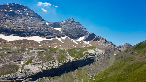

Looking towards the Spanish border from Col de Tentes (left) and back down the last few km of the climb
Suggested cycling route
This cycling route starts in Argeles Gazost and you will head along the flat valley floor until you hit the Gorge de Luz after the village of Pierefitte Nestalas. From here you climb slowly upwards for the next 30km until you reach the village of Gavarnie. Behind the village, you can view the UNESCO World Heritage-listed Cirque de Gavarnie and view France’s highest waterfall at 422m ( 1 385ft) or refuel before the climb which starts just out of the village.
I always enjoy a quick stop at Gavarnie on the way up and there is a public water fountain on the main road on the right-hand side past the Tourist office. On the way back I highly recommend a longer stop at one of the cafés in Gavarnie and enjoy the surrounding sites and mountains.
Distance: 95.7km / 59.5mi
Start elevation: 460m / 1,509ft
Max elevation: 2,206m / 7,238ft
Metres climbed: 2,313m / 7,589ft
Metres descended: 2,308m / 7,571ft
Categorised climbs: 1
Col de Tentes
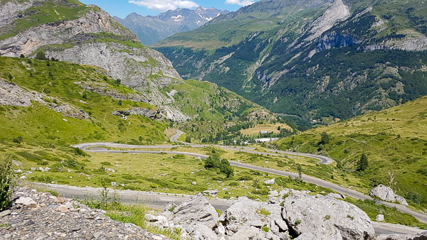
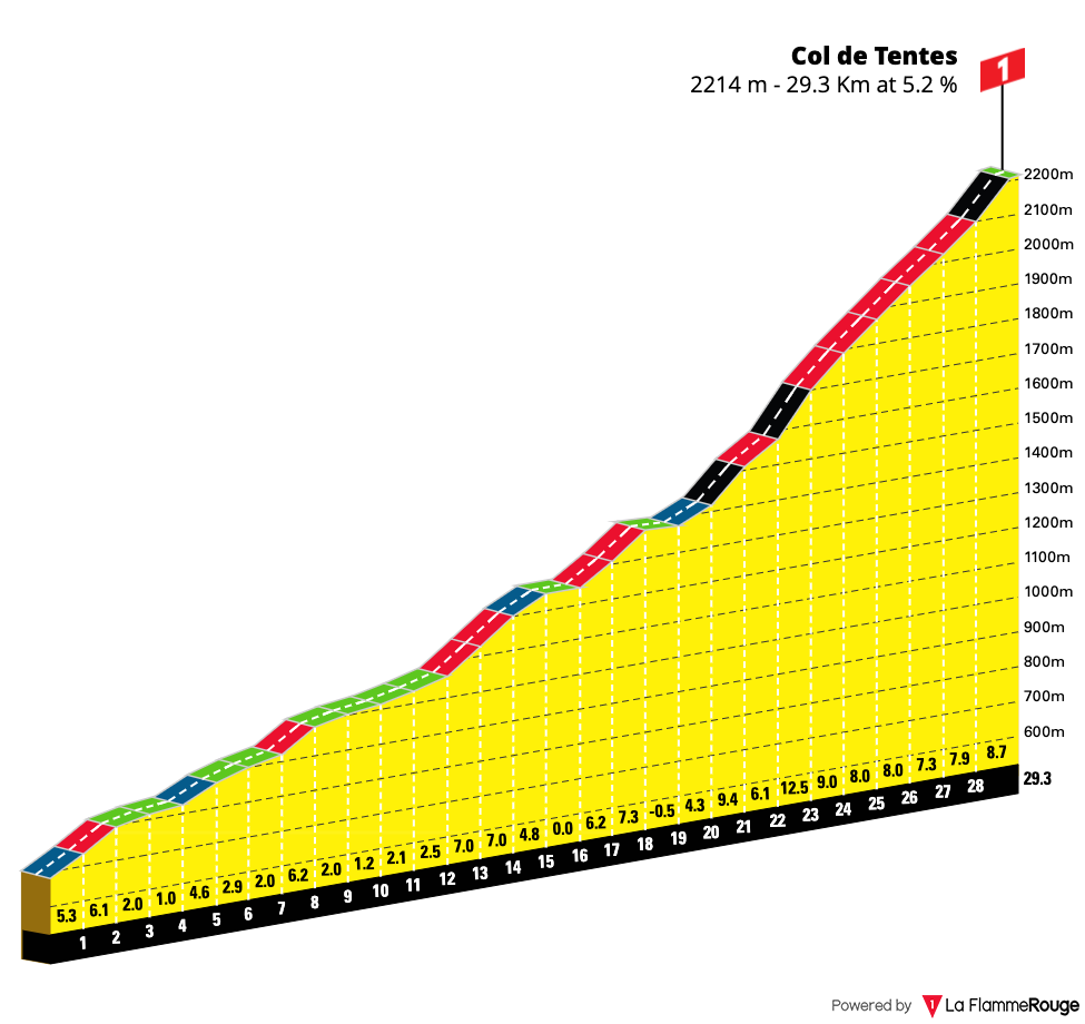
With 40kms of uphill in the legs, you could be forgiven for thinking you had already completed most of the climbing. But the road ahead tells otherwise and the official start of the Col de Tentes begins as soon as you leave Gavarnie. The climb itself is 11 km (6.7 mi) long and over that distance, you will gain another 800m of elevation. From the start, the road kicks up sharply and both times I completed it, a headwind made progress all that little bit harder.
From the bottom, you can see a statue towering overhead and after just a few kilometres of climbing you are looking down on that very statue as you gain elevation quickly. You can see the road zig-zag ahead of you, often seemingly perched on the side of a cliff. You will marvel at just how a road was carved into the mountain. A few kilometres from the top you will pass a ski station which in and of itself is quite unremarkable. As you keep making your way up the steep climb you really appreciate the beauty of this part of the national park.

I always love soaking in the views looking back down the road I have just cycled up.
The final push to the summit
In the last two kilometres to the top be aware of herds of sheep who will not move off the road. Seemingly stuck perched into little nooks in the cliff, these sheep are not at all bothered by the laboured breathing of an amateur cyclist. The views all around are spectacular especially once you reach the 2,208m summit which is higher than the Col du Tourmalet. You may also see the climb called Port de Boucharo, which is the name given to the border crossing. From here the hard work is done and it is an awesome downhill descent all the way home.
I always enjoy spending some time at the top and enjoying the grandeur of the mountains that surround me. There are no facilities at the top of this climb, unlike many others, but Gavarnie is not too far away when it is all downhill.
Food and water
There are plenty of options for food and water on this route. Luz Saint Sauveur is the first option on the way up with cafés and supermarkets. Further up you pass the small village of Gèdre where you will find a small general store and a few café options. The next stop is Gavernie where there are a number of cafés and small stores for resupply. All three villages have public toilets.
Highlights
- Gavarnie is a world UNESCO heritage site and home to France’s highest waterfall.
- Wonder at the spectacular road which climbs sharply to the top of the Col de Tentes.
- Reaching the highest paved road in the Pyrenees at 2 208m (7 244ft)- higher than the Tourmalet!
Climb statistics and gradient profile
Col de Tentes
Length: 10.8km / 6.72mi
Average gradient: 7.71%
Start point: Gavarnie
Elevation at top: 2,208m / 7,244ft