
Cycling Les Deux Alps
As with Alpe d’Huez, Les Deux-Alpes is a ski resort in the Oisans region of the French Alps and was the scene of Marco Pantani’s famous Tour de France winning victory in 1998. The route we have mapped out below sees you cycling to Les Deux-Alpes. Bourg d’Oisans has been used as the start and endpoint of this out and back cycling route but you could easily start this ride from anywhere along the valley.
The first section is relatively flat and provides you with a good warm-up before you take a left turn and the climbing begins. This is the same road as the Col du Lautaret and hence is quite busy at the start. Once you reach he Lac du Chambord at Le Freney d’Oisans you will take a urn on the D213. You will leave the busy traffic behind you now as you begin the climb to the summit of Les Deux-Alpes.
Suggested cycling route
Distance: 49.7km / 31mi
Start elevation: 721m / 2,365ft
Max elevation: 1,663m / 5,456ft
Metres climbed: 1,431m / 4,695ft
Metres descended: 1,431m / 4,695ft
Categorised climbs: 1

Climb statistics and gradient profile
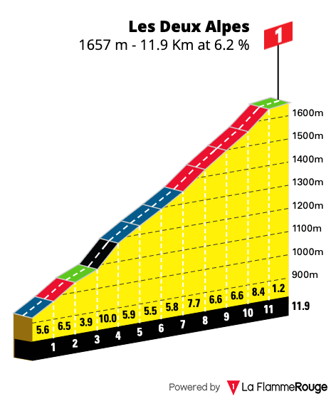
Les Deux Alpes
Length: 11.9km / 7.5mi
Average gradient: 6.2%
Start point: Le Freney d’Oisains
Elevation at top: 1,663m / 5,456ft
Food and water
We recommend topping up with food and water before setting off from Bourg d’Oisans.
You can also resupply at Le Freney d’Oisans before beginning the climb to Les Deux-Alpes.