
Col du Galibier from Le Bourg d’Oisains
The Tour de France first sent riders to the top of the Galibier in 1911 and since then many thousands of cyclists have tested themselves on this famous climb. Topping out at 2642m the Galibier is also one the highest paved roads in all of Europe. This route begins from Bourg d’Oisans and will see you cycling the Galibier via Lautaret. Read on below to discover more about this ride.

Suggested cycling route
Distance: 96km / 59.6mi
Start elevation: 725m / 2,389ft
Max elevation: 2,642m / 8,668ft
Metres climbed: 2,927m / 9,602ft
Metres descended: 2,927m / 9,602ft
Categorised climbs: 2
Col du Lautaret – First mountain pass of the day
The first five kilometres of this route lead out of the beautiful village of Bourg d’Oisans on a relatively flat gradient. You will be thankful for this as after this small warm, up the road ahead is all up hill. You will have two Cols to tackle on this route the first being the Col du Lautaret. The average gradient of just under 3% is very misleading. This is a very long climb and the road climbs steeply in parts as well. There are kilometre markers at the side of the road where you can keep track of how far there is to go. Depending on how you are feeling will determine whether you are a fan of seeing these signs or not!
As you climb up through the valley you will ride alongside the beautiful Lac du Chambon. Once you pass the ski resort village of la Grave you will be two thirds of the way into the Col du Lautaret. The scenery is stunning and typically alpine. Cascading waterfalls and lofty peaks are all around. Make sure to let your surroundings distract you from all the climbing.
Be mindful of the busy road and tunnels
The Col du Lautaret is a very busy road which takes drivers from France to Italy. Take it as a given that you are sure to meet a lot of traffic on this route. At times the smell of exhaust fumes can be a bit overwhelming. You will also have several tunnels to navigate through. We recommend you carry front and rear lights on your bike when cycling the Col du Lautaret. Some of the tunnels are not lit up so it can become disorientating to not be able to see clearly ahead of you. You will note at each of the entrances there is an indication of the tunnel length and as you ride through them you will come across other signs letting you know how long until the end of the tunnel.
Summit – Col du Lautaret 2058m
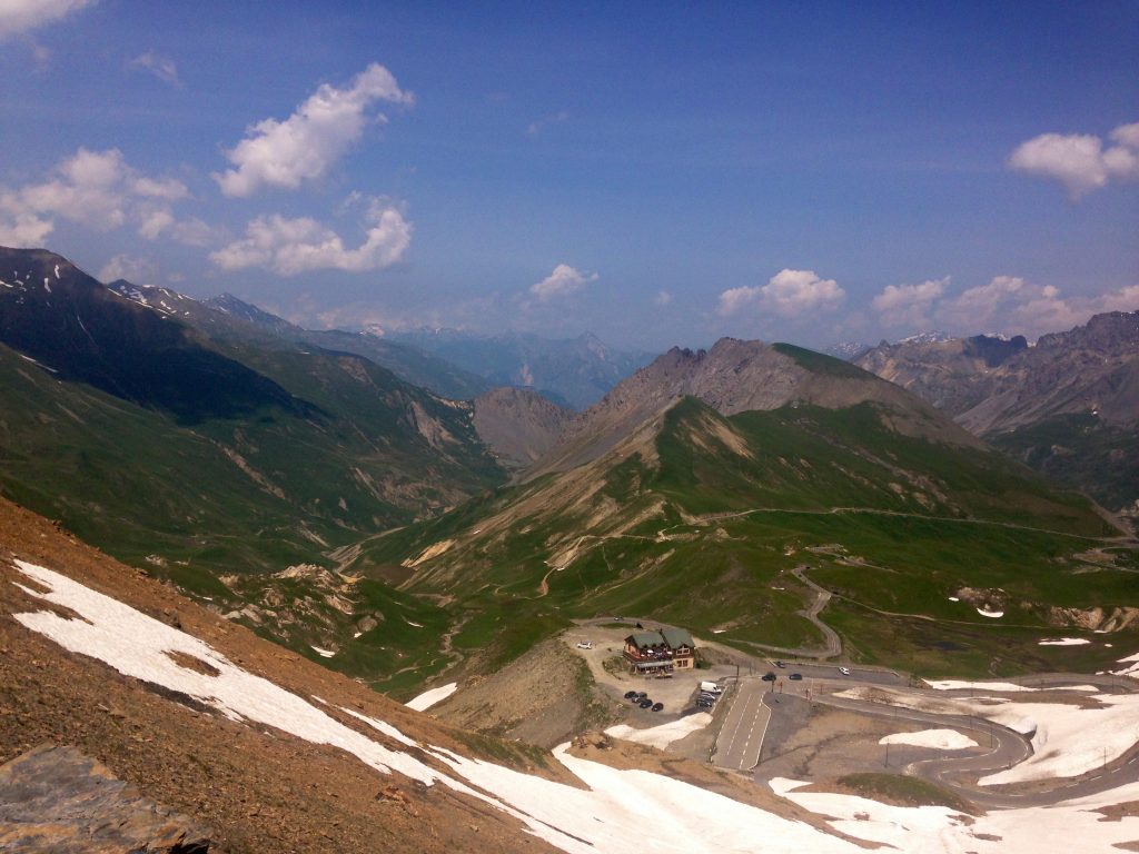
As you near the top of the Col du Lautaret you will be in amongst the alpine meadows. Lush, green pastures surround the road. Once at the summit you can choose to either take a small break and resupply at the cafes and food vendors on the side of the road or keep on pushing on for the remaining 8.5kms to the top of the Galibier. At the summit you will already be well over 2000m/8660ft of elevation so be sure to take this into account. Cycling at altitude can be quite hard going and this adds an extra layer of complexity to climbing the Galibier.
Col du Galibier – A Giant of the French Alps at 2642m
The Col du Galibier climb is not overly long in itself but with the climb of the Col du Lautaret already in the legs, it can be quite a strain. In contrast to the Col du Lautaret, the road leading to the summit is very quiet and devoid of traffic. The scenery is also breathtaking. The first few kilometres of the climb wind through beautiful meadows and the views are really out of this world. You can get a real appreciation for just how up you are with views of large mountain peaks down into the horizon.
As you keep making your way up the climb the mountain begins to transform. Those lush green meadows at the start are now replaced with rocks, as the road snakes its way to the top. remnants of paint on the road remind you of the climbs pedigree in the Tour de France. Just a kilometre from the top you will reach a monument to Henri Desgranges. A good distraction as the steepest gradients of the climb are now upon you. You will pass the tunnel in the right and start to tackle tight hairpins. The double digit gradients at this elevation really hurt as you make your up the road which is seemingly perched on the side of a cliff. You will be so pleased to reach the summit. Take in those well earned summit views and enjoy the almost 50km descent back to Bourg d’Oisans the way you came!
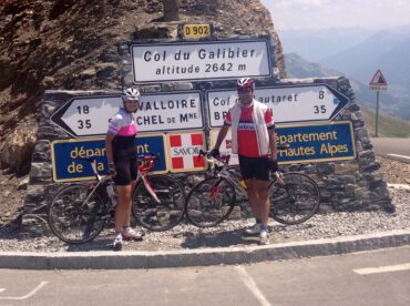
Not many Cols in Europe have a higher elevation than the Galibier!
Food and water
This is a long ride so be sure to take plenty of food and water with you. There are several resupply points along the way. These are located at the village of La Grave and also at thesummit of the Col du Lauteret. There is also the Chalet du Galibier located just 1km from the summit of the Galibier, near the monument to Henri Desgranges.
Highlights
- Riding across one of the highest paved roads in Europe. The Galibier climb has some of the best views of the surrounding Alps.
- Cycling the Galibier via the Lauturet means you tick off two Tour de France rides in one go.
- Riding beside the stunning Lac du Chambon as you climb the pass of the Col du Lauteret.

There are big bikes at the top of the Col du Lautaret as well as places to purchase food and water.
Col du Lautaret
Length: 48km / 29.8mi
Average gradient: 2.77%
Start point: Borg d’Oisains
Elevation at top: 2058m / 8,668ft
Col du Galibier
Length: 8.5km / 5.3mi
Average gradient: 8.5%
Start point: Col du Lauteret
Elevation at top: 2642m / 8,668ft


Discover our comprehensive guide to Cycling in the French Alps
This cycling route is just one of many great cycling rides near the small village of Bourg d’Oisans which you can enjoy. This area of the French Alps is very popular with cyclists year round owing to the great weather and variety of terrain on offer.
If you are not familiar with cycling in the French Alps then our comprehensive guide will help you plan everything you need for your cycling holiday. The guide includes information such as:
- a map of the French Alps with climbs and towns marked
- where to base yourself whist on your cycling holiday
- cycling hotels and lodges
- bike hire outlets
- overview of transport links to the main areas in the Alps
- non-cycling attractions and activities in the region
Click here to see a full list of cycling routes available in the French Alps.