
A Guide to Cycling the Col du Granon
Col du Granon – a lesser known Tour de France climb
Whilst relatively unknown compared to its more famous neighboring climbs, there are not many alpine passes that are higher than the Col du Granon. It appeared in the 1986 edition of the Tour de France where it remained the highest summit finish of a stage until the Tour finished on the Galibier in 2011.
Suggested cycling route
Distance: 35.7km / 22.2mi
Start elevation: 1335m / ft
Max elevation: 2413m / 7917ft
Metres climbed: 1265m / 4150ft
Metres descended: 1265m / 4159ft
Categorised climbs: 1
Tackle the steep Gradients of the Col du Granon
Whilst not the longest of climbs, what the Col du Granon lacks in length it more than makes up for in steep, punchy gradients. You will at times feel like you are barely making progress as the gradient hovers into double digits for long sections. Keep in mind if you are riding this climb in the height of summer that the blistering heat and wind which often sweeps through these parts, will make the task at hand that bit harder. The road is quieter than many of the other passes in the area so you can at least enjoy riding with relatively little traffic around.
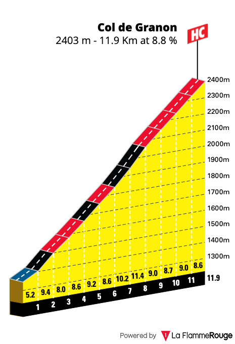
While cycling the Col du Granon climb, you will notice roadside markers each kilometer. These indicator boards are available on the famous Tour de France climbs in the region and let you know what the next section has in store for you by means of the average gradient. No doubt you’ll be cursing the signs as they continually say, 9, 10, and even 11%! Try to let the views out across to the more famous Galibier and back down to Briançon to distract your mind from the testing average gradient. Halfway up the climb, you will hit a sustained steep section averaging over 11%. There is nothing for it but just to grind it out slowly.
Descend the way you came or take on the gravel?
As you start to spot glaciers in the distance you will really start to believe you are at the top of the world. Finally, you reach the summit. All that greets you is a small cafe and the summit sign. Take extra time at the summit to take stock of where you have come from. As only one side of the pass is paved, we have chosen to route this as an out and back ride. If you are riding a gravel or mountain bike, it is possible to continue over the top of the pass and descend down to the ski resort of Val de Prés. From there you can then head back on the D994G road to Briançon. Either way, you will have a steep descent all the way to the end.
There are not many climbs in Europe which are higher than the summit of the Col du Granon
Food and water
Top up with food and water at either Briançon or Saint-Chaffron before making your way up the climb of the Col du Granon.
There is also a cafe at the summit where you can purchase food and drinks before the descent.
Highlights
- Whilst relatively unknown compared to it’s more famous neighbouring climbs, there are not many alpine passes which are higher than the Col du Granon.
Double-digit gradients are prevalent on the climb to the Col du Granon.
Col du Granon
Length: 11.5km / 7mi
Average gradient: 9.2%
Start point: Saint Chaffrey
Elevation at top: 2413m / 7917ft
Discover our comprehensive guide to Cycling in the French Alps
The ride of the Col du Granon is just one of many great cycling routes near the town of Briançon in the Serre Chevalier Valley. This area of the French Alps is very popular with cyclists owing to the famous Tour de France mountain passes close by
If you are not familiar with this region then, our comprehensive guide will help you plan everything you need for your cycling holiday. The guide includes information such as:
- a map of the French Alps with climbs and towns marked
- where to base yourself whist on your cycling holiday
- cycling hotels and lodges
- bike hire outlets
- getting to and from Nice
- non-cycling attractions and activities in the region
Click here to see a list of cycling routes available from the Serre Chevalier Valley.
Our cycling route suggestions start in Briançon as we know from experience the majority of people visiting the area will stay in, or close to this town.