
A Guide to Cycling the Plaine Joux climb
The Plaine Joux climb is located in the Haute-Savoie department in the French Alps. Plaine Joux functions as a cross-country ski resort during winter. In the warmer months, the cross country skiers give way to hikers, cyclists, and paragliders who are often seen gliding in the skies above. There are commanding views across to Mont Blanc from the climb. Over a distance of 14km/ 8.7mi, the Plaine Joux climb has an average gradient of 5.6% and you will ascend 784m / 2,572ft in elevation to reach the summit.
Plaine Joux Climb Statistics and gradient profile
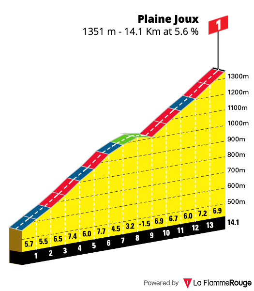
Length: 14.1km / 8.7mi
Average gradient: 5.6%
Start point: 589m / 1,932ft
Elevation at top: 1,351m / 4,432
Category: Category 1
Cycling Route – Chamonix to Plaine Joux return
Ride distance: 72km / 45mi
Elevation gain: 1,865m / 6,119ft
Nearest town: Passy
Facilities at top: Yes – food and water
When to ride: May to October
Road condition: Asphalt – Good
Nearest climb: Col des Aravis
Number of approaches: 2
Through road at top: No
Downhill to begin with
The cycling route we have mapped out starts and finishes in Chamonix. Of course, you can alter this to begin from any of the villages in the Chamonix Valley depending on where you are staying. The ride can be broken down into three sections. The first is predominantly downhill as you depart Chamonix and descend to the village of Passy. The descent here is mainly on forested roads and with a few switchbacks to negotiate is a great way to start the ride.
The Plaine Joux climb
Once you reach Passy the second section of the route begins. This will involve the climb up and down the Plaine Joux. For the majority of the climb, you will be in the forest and it is only as you near the top that you begin to ride out into more open meadows, framed with grand peaks. The summit of the Plaine Joux is reached once you get to the car park. There are restaurants and cafes here where you can choose to refuel with food and water. On a clear day, you can look out at some of the most commanding views of Mont Blanc and spend time watching paragliders flying overhead before descending back the way you came.
One last climb on the return back to Chamonix
The third and final section of this cycling route is the uphill return trip from Passy back to where the ride began in Chamonix. Whilst this climb doesn’t end grand view and a photo opportunity of yourself standing proudly at the summit sign of a famous col, it should not be underestimated. There are some steep sections to negotiate here and you will also have the climb of the Plaine Joux in the legs as well. This final climb is also slightly longer in length than the Plaine Joux, although the average gradient overall is more gentle at 4.4%. Once over the final climb, you will enjoy a short descent to Les Houches and then continue on the final few remaining kilometers back to Chamonix.
Route Variation
If you want a shorter ride an option is to catch the train from Chamonix all to way to Saint Gervais les Bains. From the station, you will be left with a nice warm-up of just over 5kms to the base of the climb itself. This will give you a ride with an overall distance of approximately 30km / 18.5mi and just under 1000m / 3,280ft of climbing all up.

Above: Views like these across to the Mont Blanc Massif will be a constant on this cycling route.
Bottom Left: In the Haute Savoie, a mountain peak reveals itself around every corner.
Bottom Right: The shade provided by the forest roads will be very welcome on a hot summer’s day.


Other routes to ride near the Plaine Joux climb
There are no shortage of climbs in this area of the French Alps. Listed below are some other climbs which you could choose to explore whilst holidaying in the Chamonix Valley. Each of the climbs listed below has a dedicated cycling guide that will outline the route in more detail so you can better plan your rides. To explore all the rides in this region of the French Alps you can also consult our Chamonix Valley Ride Guide.
Col des Aravis
The Col des Aravis is a Category 1 climb and has been a regular feature in the Tour de France. It has been used in the race 41 times, most recently in 2020 where Richard Carapaz was the first rider to reach the summit. The climb is located on the Route des Grandes Alpes and links the Savoie and Haute-Savoie region of the French Alps. The Southern Approach from Flumet is the more difficult side of this climb despite a seemingly mild average gradient of just 4.9%. The second half of the climb regularly has sections of road which reach double-digit gradients. Click here to discover the climb of the Col des Aravis in more detail.
Col de la Colombière
The Col de la Colombière has featured in the Tour de France on 22 occasions. Located in the Haute Savoie region of the French Alps, it was last used on stage 10 of the 2018 edition where Julian Alaphilippe was leader over the summit. The climb from Le Grand Bornard is 11.7km / 7.2mi long and has an average gradient of 5.9%. From Chamonix, it is possible to ride the Col de la Colombière as part of a grand circuit which also takes in the climb of the Col des Aravis. You can discover more about this challenging route on our dedicated Cycling Guide.
Plan your cycling holiday to the Chamonix Valley
If you are not familiar with the Chamonix Valley, our comprehensive guide will help you plan everything you need for your cycling holiday. The guide includes information such as:
- a map of the Chamonix Valley with climbs and towns marked
- ideas of where to base yourself depending on which mountains you would like to ride
- A list of cycling hotels and lodges in the area
- links to bike hire outlets
- Information about getting to and from the Chamonix Valley and transport connections
- Ideas of non-cycling attractions and activities in the region